Page last updated on March 17, 2026 at 1:26 pm
Vision Statement
The Rogers St./Madison St./Kinser Pk. corridor will become a safe, accessible, and connected multimodal street that supports existing neighborhoods, advances Bloomington's values, and guides future growth toward walkable, people-centered places.
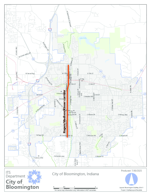
Study Area
The Rogers St./MadisonSt./Kinser Pk. corridor is a single north/south street that spans Bloomington city limits. The corridor study area includes the 4.1 mile segment between Country Club Drive on the south end and the State Road 45/46 Bypass on the north end.
How to be Involved
You are invited to be part of our planning process. There are many opportunities for residents to engage and provide input based on your own lived experience in Bloomington. Your input will be used to help determine needs, weigh trade-offs, and design a street that meets the needs of the community.
- Corridor Study Updates: sign up for occasional emails to stay updated on the study and learn about upcoming involvement opportunities
- Public Workshop: Project Overview and Existing Conditions Feedback
- Wednesday, March 25 from 5:30 - 7:30pm
- Switchyard Park Pavilion
- 1601 S Rogers St., Bloomington, IN 47403
- Online Survey: Existing Conditions Feedback
- Join a Stroll and Discuss: Meet City staff for a walk along the corridor to discuss what about the corridor is working now and what could improve.
- Tuesday, March 24 from 10:30am - 12:00pm
- Meeting place: outside The Mill - 642 N Madison St.
- Travel Area: 3rd St. - 11th St.
- Wednesday, March 25 from 1:30pm - 3:00pm
- Meeting place: outside the Marathon Gas Station at 17th St./Madison St. - 401 W 17th St.
- Travel Area: 17th St. - Gourley Pk.
- Tuesday, March 24 from 10:30am - 12:00pm
If you have any direct questions or comments about this project, please email the Project Manager, Hank Duncan, at [email protected].
Study Timeline
Vision and Goals Development
- Steering Committee Meeting #1 rescheduled to March 3, 2026 due to weather
Data Collection and Corridor Analysis
- Steering Committee Meeting #1
- March 3, 2026 at 5:30pm in the City Hall McCloskey Room
- Steering Committee Meeting #1
Alternatives Development
- March - April, 2026
- Steering Committee Meeting #2
- Monday, March 23 at 5:30pm in the City Hall McCloskey Room and via Zoom
Concept Design
- May - June, 2026
- Steering Committee Meeting #3
- Date and Time TBD
- Steering Committee Meeting #3
- May - June, 2026
Final Corridor Study
- June - August, 2026
- Steering Committee Meeting #4
- Date and Time TBD
- Steering Committee Meeting #4
- June - August, 2026
Study Goals
- Eliminate Fatal and Serious Injury Crashes
- Identify and prioritize street and infrastructure changes that reduce deadly and serious crashes for everyone, in line with Bloomington's Safe Streets for All Safety Action Plan.
- Support Multimodal Travel for All Ages and Abilities
- Design a corridor that is safe, comfortable, and accessible for everyone - whether walking, rolling, taking transit, or driving - while ensuring people of all abilities and ages can easily reach key destinations.
- Align Street Design with Existing and Planned Development
- Ensure the corridor's design supports current land use patterns and planned or emerging development by improving access, safety, and connectivity while guiding growth toward people-focused outcomes.
- Deliver Cost-Effective, Implementable Improvements
- Develop a feasible conceptual design and implementation strategy that prioritizes near-term, cost-effective improvements while establishing a clear framework for long-term investments as development and funding opportunities evolve.
- Build Community Consensus Though Inclusive Engagement
- Engage residents, businesses, and other stakeholders throughout the study to establish shared goals, address concerns, and ensure the final conceptual design reflects community values and lived experience.
- Support Economic Vitality and Community Development
- Design the corridor and adjacent land use policies to encourage economic activity and reinvestment while ensuring new development supports safe streets, walkable access, and the character of surrounding neighborhoods.
Design Objectives
- Reflect Community Values and Corridor Identity
- Design alternatives shall be informed by community input and lived experience, respond to local concerns, reinforce neighborhood character, and advance a shared vision for the corridor's future.
- Advance Safety Through Proven Street Design
- Design alternatives shall prioritize proven safety countermeasures that reduce fatal and serious injury crashes, such as shorter pedestrian crossings, protected intersections, visibility improvements, pedestrian lighting, and signal timing strategies that manage or eliminate conflicts.
- Create a Context Sensitive Street that Calms Traffic
- The corridor design shall encourage operating speeds that reflect the surrounding neighborhood context, employment areas, and redevelopment districts through roadway design, lane configuration, and traffic calming measures.
- Build a Continuous Multimodal Corridor for All Users
- Design alternatives shall provide connected and intuitive facilities that support walking and the citywide bicycle and transit network by minimizing gaps, conflict points, and uncertainty for users of all ages and abilities.
- Ensure Universal Accessibility and Comfort
- Design alternatives shall meet or exceed ADA and PROWAG standards by providing accessible crossings, sidewalks, transit stops, and public spaces the accommodate people experiencing disabilities and with assistive mobility devices.
- Support Redevelopment and Local Economic Vitality
- Design alternatives shall support the Hopewell and Trades District developments by providing safe, multimodal connections, context-sensitive access, and street designs that reinforce the goals of these key developments.
- Strengthen Connections to Key Destinations and the Citywide Network
- Design alternatives shall improve safe and direct connections to downtown Bloomington, surrounding neighborhoods, schools, parks, transit routes, and planned developments along the corridor.
- Support Safe Routes to School
- Design alternatives shall support safe walking and biking for students traveling to and from school.