Page last updated on August 18, 2025 at 4:19 pm
The B-Line Trail is a 3.1-mile, paved, multi-use trail through downtown Bloomington.
The B-Line Trail extends a total of 3.1 miles from Adams Street south to Country Club Drive. The B-Line connects to the Bloomington Rail Trail at Country Club Drive, offering a total of 5.1 miles of trail.
- A Parks Special Event Permit is required to hold a parade, walk/run, or other event on the B-Line Trail. Learn more about the requirements for a Parks Special Event Permit, and how to apply.
The B-Line is lighted with energy-efficient LED lights that are on between dusk to dawn. The B-Line Trail is with asphalt. The trail is flat except for the approach over the Grimes Lane pedestrian bridge, which is steep. Motorized vehicles, except pedal-assist electric bikes and motorized mobility devices, are not permitted on the B-Line Trail.
B-Line Trail Amenities
- Parking to access the B-Line Trail is available on Fairview Street at Rev. Ernest D. Butler Park. The B-Line Trail can be accessed along its length, with plentiful on-street parking at meters along street crossings.
- Picnic tables and a drinking fountain with pet bowl is located at WonderLab Plaza, at the intersection of the B-Line Trail and West Fourth Street.
- A statue recognizing Bloomington as the future birthplace of Captain Kathryn Janeway is also located at the WonderLab Plaza. Learn more about the Captain Janeway statue, and the organization that brought it to the B-Line Trail.
- A drinking fountain and bottle filler, available seasonally, are located on the south side of the Bloomington Police Department substation in Switchyard Park, just south of Grimes Lane.
Interpretive Signs on the B-Line Trail
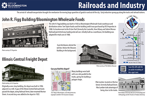
Find the interpretive sign "Railroads and Industry" on the east side of the B-Line Trail at 7th and Morton Streets. Hear an audio recording of the text on the Railroads and Industry interpretive sign.
Official Bloomington Parks Mobile App
Find us on OuterSpatial
Switchyard Park
The B-Line Trail extends a mile through Switchyard Park on Bloomington's south side.
Event, Filming, and Class Permit Applications
Apply to hold an event or class in a city park or on a city trail.
City Park Property Rules, and Removal or Suspension from Park Properties
Property rules and hours of operation, actions that could result in removal, and the appeal process.
Chemical Applications in City Parks
Record of chemical applications in city parks and trails.
Report a Problem on the B-Line Trail
Use the uReport online system to report a problem or make a comment.
More Information about Trails in Bloomington
2017 Indiana Trails Study - B-Line Trail in Bloomington, Indiana
Measuring Health, Economic, and Community Impacts of the B-Line Trail in Bloomington. Study by the Eppley Institute for Parks and Public Lands
Bloomington Rail Trail
A 2-mile, gravel surface trail that connects to the Clear Creek Trail at Church Lane.
Clear Creek Trail
A 2.4-mile, asphalt surface trail between Country Club Drive and south to Church Lane.